


Preview
Abstract
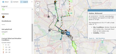
ArcGIS Map Image 3: Display of a larger scale of the ArcGIS map showing additional features such as shuttle routes and accessibility areas.. Note the addition of dynamic data sets (wind speed and Doppler radar)
Course
Adaptive Response Modeling Using GIS (UNIV 291 Sec 040)
Publication Date
September 2015
Document Type
Image
Date of Submission
November 2016
Journal/Book/Conference
Great VCU Bike Race Book
Rights
This work is licensed under a Creative Commons Attribution-NonCommercial-ShareAlike 4.0 International (CC BY-SA 4.0) License.
Is Part Of
Great VCU Bike Race Student Images
COinS