


Preview
Publisher
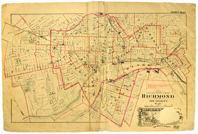
G. Wm. Baist
Creation Date
1889
Description
Outline & index map Richmond and vicinity. Including Jackson Ward, Marshall Ward, Clay Ward, Monroe Wd., Madison Wd. and Jefferson Ward, Richmond, and Henrico County, the James River, Manchester, and Chesterfield Co.
Note
Note: the red lines and figures on this map correspond with & refer to the plates in the atlas
Physical Description
1 map : hand col. ; 48 x 72 cm.
Scale
Scale 1 inch = 1000 feet
Topical Subject
Real property -- Virginia -- Richmond -- Maps
Geographical Name Subject
Richmond (Va.) -- Maps
City/Location
Richmond (Va.)
Temporal
Nineteenth century
Genre
books; maps (documents)
Local Genre
map; text
Type
Still Image; Text
Digital File Format
image/jpg
Language
eng
Rights Statement URL
Rights
This material is in the public domain in the United States and thus is free of any copyright restriction. Acknowledgement of Virginia Commonwealth University Libraries as a source is requested.
Original Title
Atlas of the city of Richmond, Virginia and vicinity; from actual surveys, official records & private plans
Collection
Baist Atlas of Richmond, VA (1889)
Source
Baist, G. Wm. 1889. Atlas of the city of Richmond, Virginia and vicinity; from actual surveys, official records & private plans. Philadelphia: G. Wm. Baist.
File Name
bai_05_index.jpg