


Preview
Publisher
G. Wm. Baist
Creation Date
1889
Plate Number
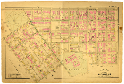
Plate 7
Description
Part of Monroe & Clay Wards Richmond. Bordered by Franklin St. to the north, 4th St. to the east, Albemarle St. and Arch St. to the south and Cherry St. to the west.
Streets
Adams St.; Albemarle St.; Arch St.; Belvidere St.; Beverly St.; Byrd St.; Cherry St.; Cumberland St.; E. Canal St.; E. Cary St.; E. Franklin St.; E. Main St.; Foushee St.; Henry St.; Jefferson St.; Laurel St.; Madison St.; Monroe St.; Morgan Alley; N. 1st St.; N. 2nd St.; N. 3rd St.; N. 4th St.; Pine St.; S. 1st St.; S. 2nd St.; S. 3rd St.; S. 4th St.; W. Canal St.; W. Cary St.; W. Franklin St.; W. Main St.
Features
Monroe Park
Physical Description
1 map : hand col. ; 48 x 72 cm.
Scale
Scale 1 inch = 150 feet
Topical Subject
Real property -- Virginia -- Richmond -- Maps
Geographical Name Subject
Richmond (Va.) -- Maps
City/Location
Richmond (Va.)
Temporal
Nineteenth century
Genre
books; maps (documents)
Local Genre
map; text
Type
Still Image; Text
Digital File Format
image/jpg
Language
eng
Rights Statement URL
Rights
This material is in the public domain in the United States and thus is free of any copyright restriction. Acknowledgement of Virginia Commonwealth University Libraries as a source is requested.
Original Title
Atlas of the city of Richmond, Virginia and vicinity; from actual surveys, official records & private plans
Collection
Baist Atlas of Richmond, VA (1889)
Source
Baist, G. Wm. 1889. Atlas of the city of Richmond, Virginia and vicinity; from actual surveys, official records & private plans. Philadelphia: G. Wm. Baist.
File Name
bai_12_plate07.jpg