


Preview
Publisher
G. Wm. Baist
Creation Date
1889
Plate Number
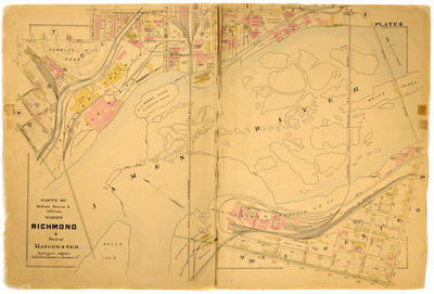
Plate 8
Description
Parts of Madison Monroe & Jefferson Wards Richmond & part of Manchester. Bordered by Byrd St. to the north, Mayo's Bridge to the east, 7th St. to the south and Belvidere St. to the west.
Streets
1st St.; 2nd St.; 3rd St.; 4th St.; 4th St. [Manchester]; 5th St.; 5th St. [Manchester]; 6th St.; 6th St. [Manchester]; 7th St.; 7th St. [Manchester]; 9th St.; 10th St.; 11th St.; 12th [St.]; Arch St.; Bainbridge St.; Belvidere St.; Bragg St.; Brander St.; Byrd St.; Church St.; Free Bridge; High St.; Howard St.; Hull St.; Mayo's Bridge; Mayo St.; McCrea St.; McDonough St.; Overton St.; Perry St.; Porter St.; Rowe St.; Sullivan Alley; Tredegar St.
Features
Gamble's Hill Park; Brown's Island; James River; Mayo's Island; Belle Isle; James River and Kanawha Canal; Mill Race
Physical Description
1 map : hand col. ; 48 x 72 cm.
Scale
Scale 1 inch = 200 feet
Topical Subject
Real property -- Virginia -- Richmond -- Maps
Geographical Name Subject
Richmond (Va.) -- Maps; Manchester (Va.) -- Maps
City/Location
Richmond (Va.); Manchester (Va.)
Temporal
Nineteenth century
Genre
books; maps (documents)
Local Genre
map; text
Type
Still Image; Text
Digital File Format
image/jpg
Language
eng
Rights Statement URL
Rights
This material is in the public domain in the United States and thus is free of any copyright restriction. Acknowledgement of Virginia Commonwealth University Libraries as a source is requested.
Original Title
Atlas of the city of Richmond, Virginia and vicinity; from actual surveys, official records & private plans
Collection
Baist Atlas of Richmond, VA (1889)
Source
Baist, G. Wm. 1889. Atlas of the city of Richmond, Virginia and vicinity; from actual surveys, official records & private plans. Philadelphia: G. Wm. Baist.
File Name
bai_13_plate08.jpg