


Preview
Other Title
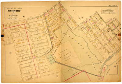
Part of Clay Ward Richmond & Upper District Henrico County
Publisher
G. Wm. Baist
Creation Date
1889
Plate Number
Plate 9
Description
Part of Clay Ward Richmond & Upper District Henrico Co. Bordered by W. Cary St. to the north, Howard St. to the east, the James River to the south and Temple St. to the west.
Streets
Albemarle St.; Ashland St.; Beach St.; Belvidere St.; Beverly St.; Blair St.; Chaffin St.; Cherry St.; China St.; Church St.; Claiborne St.; Cumberland St.; Dance St.; Dobson St.; Green St.; Holly St.; Howard St.; Jacquelin St.; Kemper St.; Laurel St.; Linden St.; Maiden Lane; Pine St.; Randolph St.; Reservior [Reservoir] St.; Rowe St.; Spring St.; Staples St.; Taylor St.; W. Cary St.; Wallace St.; Washington St.; Winder St.
Features
Hollywood Cemetery; Marshall Reservoir; James River; James River and Kanawha Canal
Physical Description
1 map : hand col. ; 48 x 72 cm.
Scale
Scale 1 inch = 200 feet
Topical Subject
Real property -- Virginia -- Richmond -- Maps
Geographical Name Subject
Richmond (Va.) -- Maps; Henrico County (Va.) -- Maps
City/Location
Richmond (Va.); Henrico County (Va.)
Temporal
Nineteenth century
Genre
books; maps (documents)
Local Genre
map; text
Type
Still Image; Text
Digital File Format
image/jpg
Language
eng
Rights Statement URL
Rights
This material is in the public domain in the United States and thus is free of any copyright restriction. Acknowledgement of Virginia Commonwealth University Libraries as a source is requested.
Original Title
Atlas of the city of Richmond, Virginia and vicinity; from actual surveys, official records & private plans
Collection
Baist Atlas of Richmond, VA (1889)
Source
Baist, G. Wm. 1889. Atlas of the city of Richmond, Virginia and vicinity; from actual surveys, official records & private plans. Philadelphia: G. Wm. Baist.
File Name
bai_14_plate09.jpg