


Preview
Other Title
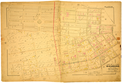
Part of Clay Ward Richmond Upper District Henrico County
Publisher
G. Wm. Baist
Creation Date
1889
Plate Number
Plate 10
Description
Part of Clay Ward Richmond Upper District Henrico Co. Bordered by Broad St. to the north, Laurel St. to the east, W. Cary St. to the south and Sycamore St. to the west.
Streets
Allen Ave.; Beach St.; Birch St.; Boyd St.; Broad St.; Cherry St.; Floyd St.; Grace St.; Grove Ave.; Hanover; Harrison St.; Harvie St.; Ivy St.; Laurel St.; Linden St.; Lombardy St.; Meadow St.; Monument Ave.; Morris St.; Park Ave.; Park St.; Plum St.; Proposed St.; Reservoir St.; Rowland St.; Ryland St.; Shafer St.; Short St.; Sycamore St.; Vine St.; W. Cary St.; W. Franklin St.; W. Main St.; Walnut St.; West St.
Physical Description
1 map : hand col. ; 48 x 72 cm.
Scale
Scale 1 inch = 200 feet
Topical Subject
Real property -- Virginia -- Richmond -- Maps
Geographical Name Subject
Richmond (Va.) -- Maps; Henrico County (Va.) -- Maps
City/Location
Richmond (Va.); Henrico County (Va.)
Temporal
Nineteenth century
Genre
books; maps (documents)
Local Genre
map; text
Type
Still Image; Text
Digital File Format
image/jpg
Language
eng
Rights Statement URL
Rights
This material is in the public domain in the United States and thus is free of any copyright restriction. Acknowledgement of Virginia Commonwealth University Libraries as a source is requested.
Original Title
Atlas of the city of Richmond, Virginia and vicinity; from actual surveys, official records & private plans
Collection
Baist Atlas of Richmond, VA (1889)
Source
Baist, G. Wm. 1889. Atlas of the city of Richmond, Virginia and vicinity; from actual surveys, official records & private plans. Philadelphia: G. Wm. Baist.
File Name
bai_15_plate10.jpg