


Preview
Other Title
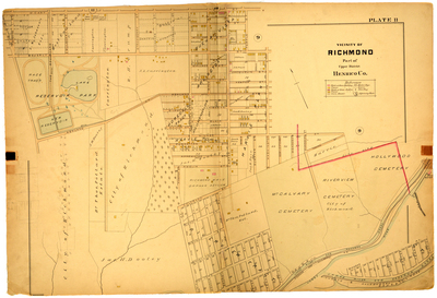
Vicinity of Richmond part of Upper District Henrico County
Publisher
G. Wm. Baist
Creation Date
1889
Plate Number
Plate 11
Description
Vicinity of Richmond part of Upper District Henrico Co. Bordered by W. Cary St. to the north, Washington St. to the east, the James River to the south and Public Road to the west.
Streets
Amelia St.; Appomatox St.; Ashland St.; Beverly St.; Blair St.; Carter Ave.; Carter St.; Chaffin [St.]; Claiborne St.; Colorado Ave.; Dakota Ave.; Dance St.; Eggleston St.; Florida Ave.; Foushee St; Gates St.; Georgia Ave.; Gilbert St.; Hampton St.; Jacquelin St.; Kansas Ave.; Kemper St.; Maryland Ave.; Meade St.; Meadow Av.; Mulberry St.; Nevada Ave.; New York Ave.; Pennsylvania Ave.; Powhattan St.; Public Road; Randolph St.; Ritchie St.; Robinson or Meadow St.; Rowland St.; Strawberry St.; Sumpter St.; Sycamore St.; Taylor St.; Temple St.; Texas Ave.; The Boulevard; Tobacco St.; Ginia [Virginia] Ave.; W. Cary St.; Walker St.; Wallace St.; Washington St.; Williams St.; Winder St.
Features
Reservoir Park; Mt. Calvary Cemetery; Riverview Cemetery; Hollywood Cemetery; James River and Kanawha Canal; James River
Physical Description
1 map : hand col. ; 48 x 72 cm.
Topical Subject
Real property -- Virginia -- Richmond -- Maps
Geographical Name Subject
Richmond (Va.) -- Maps; Henrico County (Va.) -- Maps
City/Location
Richmond (Va.); Henrico County (Va.)
Temporal
Nineteenth century
Genre
books; maps (documents)
Local Genre
map; text
Type
Still Image; Text
Digital File Format
image/jpg
Language
eng
Rights Statement URL
Rights
This material is in the public domain in the United States and thus is free of any copyright restriction. Acknowledgement of Virginia Commonwealth University Libraries as a source is requested.
Original Title
Atlas of the city of Richmond, Virginia and vicinity; from actual surveys, official records & private plans
Collection
Baist Atlas of Richmond, VA (1889)
Source
Baist, G. Wm. 1889. Atlas of the city of Richmond, Virginia and vicinity; from actual surveys, official records & private plans. Philadelphia: G. Wm. Baist.
File Name
bai_16_plate11.jpg