


Preview
Other Title
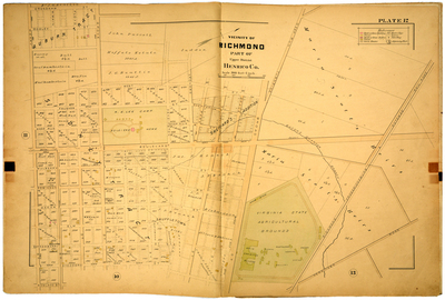
Vicinity of Richmond part of Upper District Henrico County
Publisher
G. Wm. Baist
Creation Date
1889
Plate Number
Plate 12
Description
Vicinity of Richmond part of Upper District Henrico Co. Bordered by Richmond Fredericksburg & Potomac Rail Road to the north, Hermitage Road to the east, W. Cary St. to the south and Crenshaw St. to the west.
Streets
Broad St.; Cedar St.; Crenshaw St.; Deep Run St.; Deep Run Turnpike; Dooley St.; Elm St.; Faushee St.; Floyd St.; Franklin St.; Grace St.; Grove St.; Hanover St.; Hermitage Road; Ivy St.; Kensington St.; Leonard St.; Mulberry St.; Park Ave.; Robinson St.; Rowland St.; Sheppard St.; Strawberry St.; Sycamore St.; The Boulevard; W. Cary St.; W. Main St.; West St.
Features
Virginia State Agricultural Grounds; R. E. Lee Camp Soldiers Home
Physical Description
1 map : hand col. ; 48 x 72 cm.
Scale
Scale 1 inch = 300 feet
Topical Subject
Real property -- Virginia -- Richmond -- Maps
Geographical Name Subject
Richmond (Va.) -- Maps; Henrico County (Va.) -- Maps
City/Location
Richmond (Va.); Henrico County (Va.)
Temporal
Nineteenth century
Genre
books; maps (documents)
Local Genre
map; text
Type
Still Image; Text
Digital File Format
image/jpg
Language
eng
Rights Statement URL
Rights
This material is in the public domain in the United States and thus is free of any copyright restriction. Acknowledgement of Virginia Commonwealth University Libraries as a source is requested.
Original Title
Atlas of the city of Richmond, Virginia and vicinity; from actual surveys, official records & private plans
Collection
Baist Atlas of Richmond, VA (1889)
Source
Baist, G. Wm. 1889. Atlas of the city of Richmond, Virginia and vicinity; from actual surveys, official records & private plans. Philadelphia: G. Wm. Baist.
File Name
bai_17_plate12.jpg