


Preview
Other Title
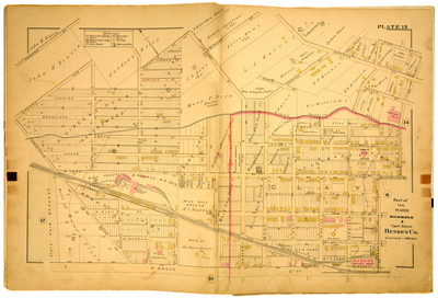
Part of Clay Ward Richmond & Upper District Henrico County
Publisher
G. Wm. Baist
Creation Date
1889
Plate Number
Plate 13
Description
Part of Clay Ward Richmond & Upper District Henrico Co. Bordered by Howard St. to the north, High St. to the east, W. Broad St. to the south and Hermitage Road to the west.
Streets
Allen (McKenzie) Ave.; Bacon St.; Bowe St.; Boyd St.; Brooke St.; Brookland St.; Carlton St.; Curie St.; Dineen St.; Duncan St.; Garden St.; Gordon Ave.; Hammond St.; Hancock St.; Harrison St.; Henrico St.; Hermitage Road; High St.; Howard St.; Kinney St.; Lodge St.; Lombardy St.; Moore St.; Morton St.; Mozelle St.; Oak St.; Railroad Ave.; Spotswood Ave.; Thomas St.; W. Broad St.; W. Clay St.; W. Leigh St.; W. Marshall St.
Features
State Fair Grounds; Base Gall Ground
Physical Description
1 map : hand col. ; 48 x 72 cm.
Scale
Scale 1 inch = 200 feet
Topical Subject
Real property -- Virginia -- Richmond -- Maps
Geographical Name Subject
Richmond (Va.) -- Maps; Henrico County (Va.) -- Maps
City/Location
Richmond (Va.); Henrico County (Va.)
Temporal
Nineteenth century
Genre
books; maps (documents)
Local Genre
map; text
Type
Still Image; Text
Digital File Format
image/jpg
Language
eng
Rights Statement URL
Rights
This material is in the public domain in the United States and thus is free of any copyright restriction. Acknowledgement of Virginia Commonwealth University Libraries as a source is requested.
Original Title
Atlas of the city of Richmond, Virginia and vicinity; from actual surveys, official records & private plans
Collection
Baist Atlas of Richmond, VA (1889)
Source
Baist, G. Wm. 1889. Atlas of the city of Richmond, Virginia and vicinity; from actual surveys, official records & private plans. Philadelphia: G. Wm. Baist.
File Name
bai_18_plate13.jpg