


Preview
Other Title
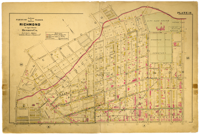
Parts of Jackson & Monroe Wards Richmond & Upper District Henrico County
Publisher
G. Wm. Baist
Creation Date
1889
Plate Number
Plate 14
Description
Parts of Jackson & Monroe Wards Richmond & Upper District Henrico Co. Bordered by Brook St. to the north, N. 5th St. to the east, Leigh St. to the south and Oak St. to the west.
Streets
Allen St.; Bacon St.; Baker St.; Bates St.; Brook St.; Brooke Ave.; Cabell St.; Calhoun St.; Caven St.; Charity St.; Clarke St.; Coutts St.; Duval St.; E. Leigh St.; Federal St.; Goddin St.; Hickory St.; Hill St.; Hospital St.; Jackson St.; Judah St.; Mitchell St.; Moore St.; N. 2nd St.; N. 3rd St.; N. 4th St.; N. 5th St.; N. First St.; New North Road; Oak St.; Orange St.; Preston St.; Price St.; Roane St.; Spring St.; St. James St.; St. John St.; St. Paul St.; St. Peters St.; Tyler St.; W. Leigh St.; Walker St.; Webster St.; Williams St.
Features
Shockoe Hill Cemetery; Potters Field; Jewish Burying Ground; Bacon Quarter Branch
Physical Description
1 map : hand col. ; 48 x 72 cm.
Scale
Scale 1 inch = 200 feet
Topical Subject
Real property -- Virginia -- Richmond -- Maps
Geographical Name Subject
Richmond (Va.) -- Maps; Henrico County (Va.) -- Maps
City/Location
Richmond (Va.); Henrico County (Va.)
Temporal
Nineteenth century
Genre
books; maps (documents)
Local Genre
map; text
Type
Still Image; Text
Digital File Format
image/jpg
Language
eng
Rights Statement URL
Rights
This material is in the public domain in the United States and thus is free of any copyright restriction. Acknowledgement of Virginia Commonwealth University Libraries as a source is requested.
Original Title
Atlas of the city of Richmond, Virginia and vicinity; from actual surveys, official records & private plans
Collection
Baist Atlas of Richmond, VA (1889)
Source
Baist, G. Wm. 1889. Atlas of the city of Richmond, Virginia and vicinity; from actual surveys, official records & private plans. Philadelphia: G. Wm. Baist.
File Name
bai_19_plate14.jpg