


Preview
Other Title
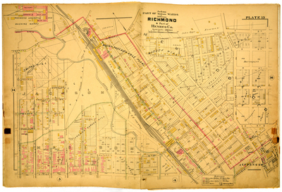
Part of Jackson Madison & Jefferson Wards Richmond & part of Henrico County
Publisher
G. Wm. Baist
Creation Date
1889
Plate Number
Plate 15
Description
Part of Jackson Madison & Jefferson Wards Richmond & part of Henrico Co. Bordered by Hospital St. to the north, 20th St. to the east, Pleasant St. to the south and N. 5th St. to the west.
Streets
19th St.; 20th St.; Abigal St.; Accomodation St.; Adams or Picke [Pickett St.]; Baker St.; Baker St. [Jackson Ward]; Balding St.; Bates St.; Bryan St.; Buchanan St.; Carrington St.; Cedar St.; Christian St.; Coalter St.; County Road; Crouch St.; Duval St.; E. Leigh St.; Fairfield Road; Federal St.; Highland Ave.; Hospital St.; James St.; Jay St.; Little Page St.; Lownes St.; M or Turpin St.; Mechanicsville Turnpike; Mosby St.; N or Ellett St.; N. 5th St.; N. 6th St.; N. 7th St.; N. 8th St.; N. 9th St.; N. 10th St.; N. 11th St.; N. 12th St.; N. 13th St; O St.; P St.; Pleasant St.; Preston St.; Q St.; R St.; Richard St.; S St.; Stewart St.; T St.; Valley or 17th St.; Venable St.; Washington or Green St.; William St.
Features
Shokoe [Shockoe] Creek; Bacon Quarter Branch
Physical Description
1 map : hand col. ; 48 x 72 cm.
Scale
Scale 1 inch = 200 feet
Topical Subject
Real property -- Virginia -- Richmond -- Maps
Geographical Name Subject
Richmond (Va.) -- Maps; Henrico County (Va.) -- Maps
City/Location
Richmond (Va.); Henrico County (Va.)
Temporal
Nineteenth century
Genre
books; maps (documents)
Local Genre
map; text
Type
Still Image; Text
Digital File Format
image/jpg
Language
eng
Rights Statement URL
Rights
This material is in the public domain in the United States and thus is free of any copyright restriction. Acknowledgement of Virginia Commonwealth University Libraries as a source is requested.
Original Title
Atlas of the city of Richmond, Virginia and vicinity; from actual surveys, official records & private plans
Collection
Baist Atlas of Richmond, VA (1889)
Source
Baist, G. Wm. 1889. Atlas of the city of Richmond, Virginia and vicinity; from actual surveys, official records & private plans. Philadelphia: G. Wm. Baist.
File Name
bai_20_plate15.jpg