


Preview
Other Title
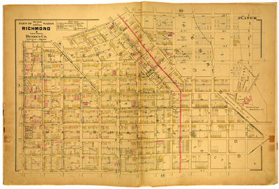
Part of Marshall & Jefferson Wards Richmond & Lower District Henrico County
Publisher
G. Wm. Baist
Creation Date
1889
Plate Number
Plate 16
Description
Part of Marshall & Jefferson Wards Richmond & Lower District Henrico Co. Bordered by U. St. to the north, 30th St. to the east, E. Broad St. to the south and Adams or Pickett St. to the west.
Streets
20th St.; 21st St.; 22nd St.; 23rd St.; 24th St.; 25th St.; 26th St.; 27th St.; 28th St.; 29th St.; 30th St.; Adams or Pickett St.; Burton St.; Carrington St.; Church Hill Ave.; Concordance St.; E. Broad St.; E. Clay St.; E. Leigh St.; E. Marshall St.; Jessamine St.; M St.; N St.; New Bridge Road; O St.; P St.; Pink or Tyler St.; Pleasant St.; Q St.; R St.; Rose St.; S St.; Scott St.; Short St.; T St.; Tulip St.; U St.; Venable St.
Physical Description
1 map : hand col. ; 48 x 72 cm.
Scale
Scale 1 inch = 200 feet
Topical Subject
Real property -- Virginia -- Richmond -- Maps
Geographical Name Subject
Richmond (Va.) -- Maps; Henrico County (Va.) -- Maps
City/Location
Richmond (Va.); Henrico County (Va.)
Temporal
Nineteenth century
Genre
books; maps (documents)
Local Genre
map; text
Type
Still Image; Text
Digital File Format
image/jpg
Language
eng
Rights Statement URL
Rights
This material is in the public domain in the United States and thus is free of any copyright restriction. Acknowledgement of Virginia Commonwealth University Libraries as a source is requested.
Original Title
Atlas of the city of Richmond, Virginia and vicinity; from actual surveys, official records & private plans
Collection
Baist Atlas of Richmond, VA (1889)
Source
Baist, G. Wm. 1889. Atlas of the city of Richmond, Virginia and vicinity; from actual surveys, official records & private plans. Philadelphia: G. Wm. Baist.
File Name
bai_21_plate16.jpg