


Preview
Other Title
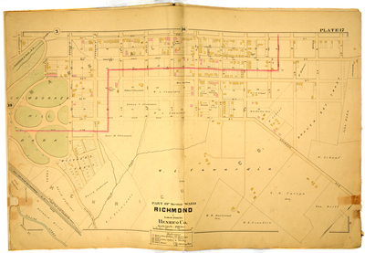
Part of Marshall Ward Richmond & Lower District Henrico County
Publisher
G. Wm. Baist
Creation Date
1889
Plate Number
Plate 17
Description
Part of Marshall Ward Richmond & Lower District Henrico Co. Bordered by T St. to the north, Oakwood Ave. to the east, Brown St. to the south and 30th St. to the west.
Streets
30th St.; 31st St.; 32nd St.; 33rd St.; 34th St.; Brown St.; E. Broad St.; E. Clay St.; E. Franklin St.; E. Grace St.; E. Leigh St.; E. Marshall St.; Jones St.; M St.; N St.; O St.; Oakwood Ave.; P St.; Q St.; R St.; S St.; T St.
Features
Chimboraza Hill Park; Gillies Creek
Physical Description
1 map : hand col. ; 48 x 72 cm.
Scale
Scale 1 inch = 200 feet
Topical Subject
Real property -- Virginia -- Richmond -- Maps
Geographical Name Subject
Richmond (Va.) -- Maps; Henrico County (Va.) -- Maps
City/Location
Richmond (Va.); Henrico County (Va.)
Temporal
Nineteenth century
Genre
books; maps (documents)
Local Genre
map; text
Type
Still Image; Text
Digital File Format
image/jpg
Language
eng
Rights Statement URL
Rights
This material is in the public domain in the United States and thus is free of any copyright restriction. Acknowledgement of Virginia Commonwealth University Libraries as a source is requested.
Original Title
Atlas of the city of Richmond, Virginia and vicinity; from actual surveys, official records & private plans
Collection
Baist Atlas of Richmond, VA (1889)
Source
Baist, G. Wm. 1889. Atlas of the city of Richmond, Virginia and vicinity; from actual surveys, official records & private plans. Philadelphia: G. Wm. Baist.
File Name
bai_22_plate17.jpg