


Preview
Other Title
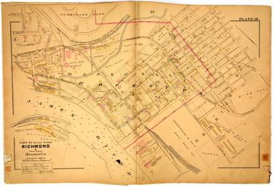
Part of Marshall Ward Richmond & Lower District Henrico County
Publisher
G. Wm. Baist
Creation Date
1889
Plate Number
Plate 18
Description
Part of Marshall Ward Richmond & Lower District Henrico Co. Bordered by E. Franklin St. to the north, Marshall St. to the east, Delaware St. to the south and Public Road to the west.
Streets
3rd St.; 4th St.; 5th St.; 6th St.; 7th St.; 8th St.; 30th [St.]; 31th [31st St.]; Ash St.; Centre St.; Delaware St.; Denny St.; E. Franklin St.; E. Main St.; Elm St.; Erin St.; Fulton St.; Gilliam St.; Goddin St.; Graham St.; Hague St.; Highland St.; Hudson St.; Lewis St.; Louisiana St.; Maple St.; Marshall St.; Nicholson St.; Ohio St.; Orleans St.; Osborne Turnpike; Poplar St.; Price St.; Public Road; Rocketts St.; Russell St.; Sharpe St.; State St.; Virginia St.; Water St.; Wharf St.; Wicker St.; Williamsburg Ave; Williamsburg Turnpike
Features
James River; Chimboraza [Hill] Park
Physical Description
1 map : hand col. ; 48 x 72 cm.
Scale
Scale 1 inch = 200 feet
Topical Subject
Real property -- Virginia -- Richmond -- Maps
Geographical Name Subject
Richmond (Va.) -- Maps; Henrico County (Va.) -- Maps
City/Location
Richmond (Va.); Henrico County (Va.)
Temporal
Nineteenth century
Genre
books; maps (documents)
Local Genre
map; text
Type
Still Image; Text
Digital File Format
image/jpg
Language
eng
Rights Statement URL
Rights
This material is in the public domain in the United States and thus is free of any copyright restriction. Acknowledgement of Virginia Commonwealth University Libraries as a source is requested.
Original Title
Atlas of the city of Richmond, Virginia and vicinity; from actual surveys, official records & private plans
Collection
Baist Atlas of Richmond, VA (1889)
Source
Baist, G. Wm. 1889. Atlas of the city of Richmond, Virginia and vicinity; from actual surveys, official records & private plans. Philadelphia: G. Wm. Baist.
File Name
bai_23_plate18.jpg