


Preview
Other Title
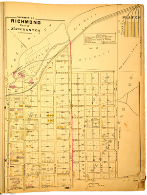
Vicinity of Richmond part of Manchester & Chesterfield County
Publisher
G. Wm. Baist
Creation Date
1889
Plate Number
Plate 19
Description
Vicinity of Richmond part of Manchester & Chesterfield Co. Bordered by the James River to the north, Pub. Road to the east, Farm Ave. to the south and Hull St. to the west.
Streets
1st or Reed St.; 1st St.; 2nd or Ludlow St.; 3rd or Wadsworth St.; 4th or Summers St.; 5th or Jackson St.; 6th or Biddle St.; 7th or Barney St.; 8th or Allen St.; 9th or Burroughs St.; 10th or Blakeey St.; Decatur St.; Everett St.; Farm Ave.; Hull St.; Lee St.; Marx St.; Maury St.; Morgan St.; Preble St.; Pub. Road; Stewart St.; Stockton St.
Features
James River
Physical Description
1 map : hand col. ; 48 x 36 cm.
Topical Subject
Real property -- Virginia -- Richmond -- Maps
Geographical Name Subject
Richmond (Va.) -- Maps; Manchester (Va.) -- Maps; Chesterfield County (Va.) -- Maps
City/Location
Richmond (Va.); Manchester (Va.); Chesterfield County (Va.)
Temporal
Nineteenth century
Genre
books; maps (documents)
Local Genre
map; text
Type
Still Image; Text
Digital File Format
image/jpg
Language
eng
Rights Statement URL
Rights
This material is in the public domain in the United States and thus is free of any copyright restriction. Acknowledgement of Virginia Commonwealth University Libraries as a source is requested.
Original Title
Atlas of the city of Richmond, Virginia and vicinity; from actual surveys, official records & private plans
Collection
Baist Atlas of Richmond, VA (1889)
Source
Baist, G. Wm. 1889. Atlas of the city of Richmond, Virginia and vicinity; from actual surveys, official records & private plans. Philadelphia: G. Wm. Baist.
File Name
bai_24_plate19.jpg