


Preview
Publisher
G. Wm. Baist
Creation Date
1889
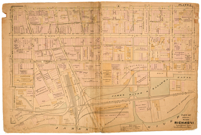
Plate Number
Plate 2
Description
Part of Jefferson Ward Richmond. Bordered by E. Franklin St. to the north, 19th St. to the east, the James River to the south and 12th St. to the west.
Streets
Creek Alley; Dock St.; E. Canal St.; E. Cary St.; E. Franklin St.; E. Main St.; Eagle Alley; Exchange Alley; Exchange or Truehart Alley; Governor St.; Locust Alley; Lombard Alley; Market St.; N. 12th St.; N. 14th St.; N. 15th St.; N. 17th St.; N. 18th St.; N. 19th St.; New St.; Shockoe Slip; So. 12th St.; So. 13th St.; So. 14th St.; So. 15th St.; So. 17th St.; So. 18th St.; So. 19th [St.]; Tobacco Alley; Virginia St.; Walnut Alley; Walnut or Arch Alley; Whitlock Alley
Features
James River and Kanawha Canal; James River
Physical Description
1 map : hand col. ; 48 x 72 cm.
Scale
Scale 1 inch = 100 feet
Topical Subject
Real property -- Virginia -- Richmond -- Maps
Geographical Name Subject
Richmond (Va.) -- Maps
City/Location
Richmond (Va.)
Temporal
Nineteenth century
Genre
books; maps (documents)
Local Genre
map; text
Type
Still Image; Text
Digital File Format
image/jpg
Language
eng
Rights Statement URL
Rights
This material is in the public domain in the United States and thus is free of any copyright restriction. Acknowledgement of Virginia Commonwealth University Libraries as a source is requested.
Original Title
Atlas of the city of Richmond, Virginia and vicinity; from actual surveys, official records & private plans
Collection
Baist Atlas of Richmond, VA (1889)
Source
Baist, G. Wm. 1889. Atlas of the city of Richmond, Virginia and vicinity; from actual surveys, official records & private plans. Philadelphia: G. Wm. Baist.
File Name
bai_07_plate02.jpg