


Preview
Publisher
G. Wm. Baist
Creation Date
1889
Plate Number
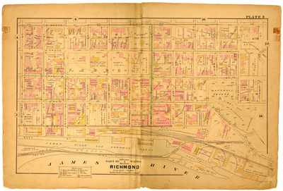
Plate 3
Description
Part of Jefferson & Marshall Wards Richmond. Bordered by E. Broad St. to the north, N. 30th Street to the east, the James River to the south and 19th St. to the west.
Streets
Bossieux Alley; Camerons Alley; Dock St.; E. Broad St.; E. Cary St.; E. Franklin St.; E. Grace St.; E. Main St.; N. 19th St.; N. 20th St.; N. 21st St.; N. 22nd St.; N. 23rd St.; N. 24th St.; N. 25th St.; N. 26th St.; N. 27th St.; N. 28th St.; N. 29th St.; N. 30th St.; Pace Alley; Pear St.; Rocketts St.; Rose Alley; So. 19th St.; So. 20th St.; So. 21st St.; So. 22nd St.; So. 23rd St.; So. 24th St.; So. 25th St.; So. 26th St.; Warehouse St.
Features
James River and Kanawha Canal; Marshall Square; Libby Hill; James River
Physical Description
1 map : hand col. ; 48 x 72 cm.
Scale
Scale 1 inch = 150 feet
Topical Subject
Real property -- Virginia -- Richmond -- Maps
Geographical Name Subject
Richmond (Va.) -- Maps
City/Location
Richmond (Va.)
Temporal
Nineteenth century
Genre
books; maps (documents)
Local Genre
map; text
Type
Still Image; Text
Digital File Format
image/jpg
Language
eng
Rights Statement URL
Rights
This material is in the public domain in the United States and thus is free of any copyright restriction. Acknowledgement of Virginia Commonwealth University Libraries as a source is requested.
Original Title
Atlas of the city of Richmond, Virginia and vicinity; from actual surveys, official records & private plans
Collection
Baist Atlas of Richmond, VA (1889)
Source
Baist, G. Wm. 1889. Atlas of the city of Richmond, Virginia and vicinity; from actual surveys, official records & private plans. Philadelphia: G. Wm. Baist.
File Name
bai_08_plate03.jpg