


Preview
Publisher
G. Wm. Baist
Creation Date
1889
Plate Number
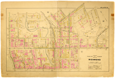
Plate 4
Description
Part of Jackson & Jefferson Wards Richmond. Bordered by E. Leigh St. to the north, N. 22nd St. to the east, E. Franklin St. to the south and Governor St. and N. 12th St. to the west.
Streets
Ballard Alley; Brown St.; Buchanan St.; Carrington St.; Central St.; Church Hill Ave.; College Alley; College St.; Cypress Alley; E. Broad St.; E. Clay St.; E. Franklin St.; E. Grace St.; E. Leigh St.; E. Marshall St.; Governor St.; Jail Alley; Jay St.; Lumpkins Alley; Mayo St.; McCance St.; Mosby St.; N. 12th St.; N. 13th St.; N. 14th St.; N. 15th St.; N. 16th St.; N. 17th St.; N. 18th St.; N. 19th St.; N. 20th St.; N. 21st St.; N. 22nd St.; Pleasant St.; Ross St.; Union St.; Valley St.
Features
Shockoe Creek
Physical Description
1 map : hand col. ; 48 x 72 cm.
Scale
Scale 1 inch = 150 feet
Topical Subject
Real property -- Virginia -- Richmond -- Maps
Geographical Name Subject
Richmond (Va.) -- Maps
City/Location
Richmond (Va.)
Temporal
Nineteenth century
Genre
books; maps (documents)
Local Genre
map; text
Type
Still Image; Text
Digital File Format
image/jpg
Language
eng
Rights Statement URL
Rights
This material is in the public domain in the United States and thus is free of any copyright restriction. Acknowledgement of Virginia Commonwealth University Libraries as a source is requested.
Original Title
Atlas of the city of Richmond, Virginia and vicinity; from actual surveys, official records & private plans
Collection
Baist Atlas of Richmond, VA (1889)
Source
Baist, G. Wm. 1889. Atlas of the city of Richmond, Virginia and vicinity; from actual surveys, official records & private plans. Philadelphia: G. Wm. Baist.
File Name
bai_09_plate04.jpg