


Preview
Other Title
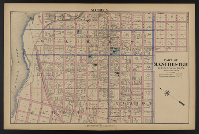
Illustrated combination atlas of Richmond, Va. 1876
Publisher
F.W. Beers
Creation Date
1876
Plate Number
Section S
Description
Published for the Southern and Southwestern Surveying and Pub. Co. by F.W. Beers.
Streets
5th or Jackson St.; 5th St.; 6th or Biddle St.; 6th St.; 7th or Barney St.; 7th St.; 8th or Allen St.; 8th St.; 9th or Burroughs St.; 9th St.; 10th or Blakley St.; 10th St.; 11th or Warrington St.; 11th St.; 12th or Lawrence St.; 12th St.; 13th or Jones St.; 13th St.; 14th or Harrison St.; 14th St.; 15th or Jefferson St.; 15th St.; 16th or Adams St.; 16th St.; 17th or Clay St.; 17th St.; Adams St.; Allen St.; Bainbridge St.; Barney St.; Biddle St.; Blakley St.; Brooke St.; Burroughs St.; Clay St.; Cowardin St.; Decatur St.; Everett St.; Harrison St.; Hull St.; Jackson St.; Jefferson St.; Jones St.; Lawrence St.; Lee St.; Madison St.; Maffitt St.; Marx St.; Maury St.; McDonough St.; Morgan St.; Perry St.; Porter St.; Powhatan St.; Semmes St.; Stockton St.; Warrington St.
Features
James River
Notable Structures
Baptist Church; City Hall; Courthouse; Episcopal Church; Methodist Episcopal Church; Masonic Hall; Presbyterian Church; Richmond & Danville Rail Road; Richmond & Petersburg Rail Road
Wards
Clay Ward; Monroe Ward
Physical Description
46 cm.
Scale
Scale 1 inch=250 feet
Topical Subject
Real property -- Virginia -- Richmond
Geographical Name Subject
Manchester (Va.) -- Maps; Chesterfield County (Va.) -- Maps
City/Location
Manchester (Va.); Chesterfield County (Va.)
Temporal
Nineteenth century
Genre
books; maps (documents)
Local Genre
map; text
Type
Still Image; Text
Digital Format
image/jpg
Language
eng
Rights Statement URL
Rights
This material is in the public domain in the United States and thus is free of any copyright restriction. Acknowledgement of Virginia Commonwealth University Libraries as a source is requested.
Original Title
Illustrated atlas of the city of Richmond, Va.
Collection
Illustrated atlas of the city of Richmond, Va.
Source
Beers, F.W. (Frederick W.). 1876. Illustrated atlas of the city of Richmond, Va. Richmond? Va. : F.W. Beers, 1876.
File Name
beers_026.jpg