


Preview
Original Title (transcribed from print)
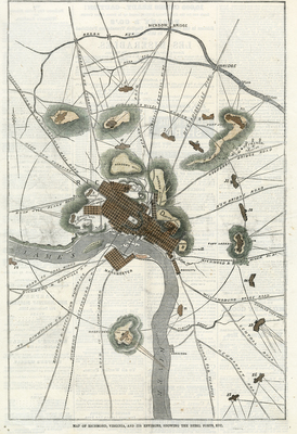
Map of Richmond, Virginia, and its environs, showing the Rebel forts, etc.
Publication
Harper's Weekly
Publisher
Harper & Brothers, Publishers
Date
12-6-1862
Page Number
780
Topical Subject
Fortification -- Virginia -- Richmond -- Maps
Geographic Subject
Virginia -- History -- Civil War, 1861-1865 -- Maps; Confederate States of America -- Defenses -- Maps; Richmond (Va.) -- Maps
City/Location
Richmond (Va.)
Original Item Size
23 x 35 cm
Genre
prints (visual works)
Local Genre
newspaper; artwork; map
Type
Still Image; Text
Digital Format
image/jpg
Language
eng
Rights Statement URL
Rights
This material is in the public domain in the United States and thus is free of any copyright restriction. Acknowledgement of Virginia Commonwealth University Libraries as a source is requested.
Collection
Richmond Nineteenth-Century Print Collection
Source
Original periodical illustration: Map of Richmond, Virginia, and its environs, showing the Rebel forts, etc., Harper's Weekly, Dec. 6, 1862, p. 780, Richmond, Virginia Maps and Prints Collection, M 190, Special Collections and Archives, James Branch Cabell Library, Virginia Commonwealth University.
File Name
rpr_harpers_weekly_18621206.jpg