


Preview
Original Title (transcribed from print)
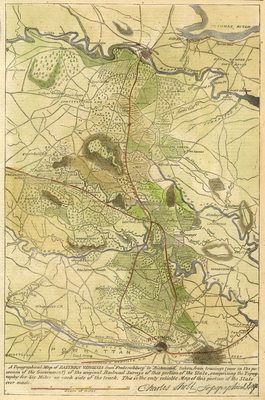
Topographical map of Eastern Virginia From Fredericksburg to Richmond taken from tracings (now in the possession of the government) of the original railroad surveys of this portion of the state, comprising the topography for six miles on each side of the track
Other Titles (transcribed from print)
A topographical map of Eastern Virginia From Fredericksburg to Richmond taken from tracings (now in the possession of the government) of the original railroad surveys of this portion of the state, comprising the topography for six miles on each side of the track
Additional Caption (transcribed from print)
This is the only reliable map of this portion of the state ever made. -- Charles Sholl, Topographical Engr.
Publication
Harper's Weekly
Publisher
Harper & Brothers, Publishers
Date
12-27-1862
Page Number
821
Geographic Subject
Virginia -- Maps
City/Location
Richmond (Va.)
Original Item Size
23 x 35 cm
Genre
prints (visual works)
Local Genre
newspaper; artwork; map
Type
Still Image; Text
Digital Format
image/jpg
Language
eng
Rights Statement URL
Rights
This material is in the public domain in the United States and thus is free of any copyright restriction. Acknowledgement of Virginia Commonwealth University Libraries as a source is requested.
Collection
Richmond Nineteenth-Century Print Collection
Source
Original periodical illustration: A topographical map of Eastern Virginia From Fredericksburg to Richmond taken from tracings (now in the possession of the government) of the original railroad surveys of this portion of the state, comprising the topography for six miles on each side of the track, Harper's Weekly, Dec. 27, 1862, p. 821, Richmond, Virginia Maps and Prints Collection, M 190, Special Collections and Archives, James Branch Cabell Library, Virginia Commonwealth University.
File Name
rpr_harpers_weekly_18621227.jpg