


Preview
Other Title
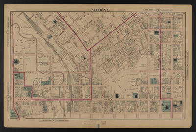
Illustrated combination atlas of Richmond, Va. 1876
Publisher
F.W. Beers
Creation Date
1876
Plate Number
Section G
Description
Published for the Southern and Southwestern Surveying and Pub. Co. by F.W. Beers.
Streets
12th St.; 13th St.; 14th St.; 15th St.; 16th St.; 17th or Valley St.; 17th St.; 18th St.; 19th St.; 20th St.; 21st St.; 22nd St.; 23rd St.; 24th St.; 25th St.; 26th St.; Adams or Pickett St.; Adams St.; Broad St.; Brown St.; Buchanan St.; Burton St.; Carrington St.; Cedar St.; Central St.; Christian St.; Clay St.; College Alley; College St.; Concord St.; Concordance St.; Ellett St.; Governor St.; Grace St.; Green St.; Harmony St.; James St.; Jay St.; Jessamine St.; Leigh St.; M St.; M or Turpin St.; Marshall St.; McCance St.; Mosby St.; Moyo St.; N St.; N or Ellett St.; O St.; Pickett St.; Pleasants St.; Randolph St.; Richard St.; Ross St.; Scott St.; Short St.; Union St.; Valley St.; Venable St.; Washington or Green St.; Washington St.; William St.
Features
Adams Cemetery; Capitol Square; Picketts Cemetery; Shockoe Creek; St. John's Burying Grounds
Notable Structures
3rd Presbyterian Church; African Baptist Church; Bellevue Public School; Central School; Chesapeake & Ohio Rail Road; Christ Episcopal Church; Church Institute; English Lutheran Church; Governors Mansion; Lancastrian School; Leigh Street Baptist Church; Masonic Hall; Medical College of Virginia; Monumental Church; St. Patrick's Church; Trinity Methodist Episcopal Church; Union Station Methodist Episcopal Church; Venable Baptist Church; Wesley Chapel
Physical Description
46 cm.
Scale
Scale 1 inch=200 feet
Topical Subject
Real property -- Virginia -- Richmond
Geographical Name Subject
Richmond (Va.) -- Maps
City/Location
Richmond (Va.)
Temporal
Nineteenth century
Genre
books; maps (documents)
Local Genre
map; text
Type
Still Image; Text
Digital Format
image/jpg
Language
eng
Rights Statement URL
Rights
This material is in the public domain in the United States and thus is free of any copyright restriction. Acknowledgement of Virginia Commonwealth University Libraries as a source is requested.
Original Title
Illustrated atlas of the city of Richmond, Va.
Collection
Illustrated atlas of the city of Richmond, Va.
Source
Beers, F.W. (Frederick W.). 1876. Illustrated atlas of the city of Richmond, Va. Richmond? Va. : F.W. Beers, 1876.
File Name
beers_013.jpg