


Preview
Other Title
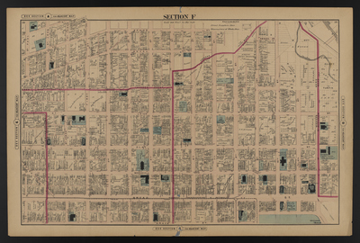
Illustrated combination atlas of Richmond, Va. 1876
Publisher
F.W. Beers
Creation Date
1876
Plate Number
Section F
Description
Published for the Southern and Southwestern Surveying and Pub. Co. by F.W. Beers.
Streets
1st St.; 2nd St.; 3rd St.; 4th St.; 5th St.; 6th St.; 7th St.; 8th St.; 9th St.; 10th St.; 11th St.; 12th St.; Abigail St.; Adams St.; Baker St.; Broad St.; Brook Ave.; Cave St.; Clarke St.; Clay St.; College Alley; Duval St.; Ellett St.; Grace St.; Jackson St.; Leigh St.; M or Turpin St.; M St.; Market Alley; Market Slip; Marshall St.; N or Ellett St.; N St.; O St.; Price St.; St. James St.; St. John St.; St. Paul St.; Sublett Alley; Turpin St.
Features
Old City Hall Lot - Public Square; Shockoe Creek
Notable Structures
3rd Baptist Church; Baker Colored School; Bayth Ahabah Synagogue; Benedictine Society; Broad Street Methodist Episcopal Church; Central School; Chesapeake & Ohio Rail Road; Clay Street Methodist Episcopal Church; Female Humane Association; First Baptist Church; First Presbyterian Church; Free Baptist Church; German Lutheran Church; German Mission Methodist Episcopal Church; Governors Mansion; Grace Street Presbyterian Church; Howitzer Armory; Leigh School; Mt. Zion African Church; Navy Hill School; Roman Catholic Church School; Richmond City Passenger Railway; Richmond Female Institute; Richmond Fredericksburg & Potomac Rail Road; St. James Episcopal Church; St. James Episcopal Home; St. Joseph Orphan Asylum; St. Marks Episcopal Church; St. Mary's Benedictine Institute; St. Mary's Roman Catholic Church; St. Paul's Church Home; St. Peters Cathedral; St. Phillips Episcopal Church; St. Sophia's Home; State Courthouse
Physical Description
46 cm.
Scale
Scale 1 inch=200 feet
Topical Subject
Real property -- Virginia -- Richmond
Geographical Name Subject
Richmond (Va.) -- Maps
City/Location
Richmond (Va.)
Temporal
Nineteenth century
Genre
books; maps (documents)
Local Genre
map; text
Type
Still Image; Text
Digital Format
image/jpg
Language
eng
Rights Statement URL
Rights
This material is in the public domain in the United States and thus is free of any copyright restriction. Acknowledgement of Virginia Commonwealth University Libraries as a source is requested.
Original Title
Illustrated atlas of the city of Richmond, Va.
Collection
Illustrated atlas of the city of Richmond, Va.
Source
Beers, F.W. (Frederick W.). 1876. Illustrated atlas of the city of Richmond, Va. Richmond? Va. : F.W. Beers, 1876.
File Name
beers_012.jpg