


Preview
Other Title
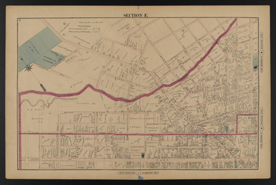
Illustrated combination atlas of Richmond, Va. 1876
Publisher
F.W. Beers
Creation Date
1876
Plate Number
Section E
Description
Published for the Southern and Southwestern Surveying and Pub. Co. by F.W. Beers.
Streets
Allen St.; Bacon St.; Baker St.; Brook Ave.; Cabell St.; Calhoun St.; Catherine St.; Charity St.; Clay St.; Coutts St.; Currie St.; Duval St.; Federal St.; Gilmer St.; Goddin St.; Graham St.; Hancock St.; Harrison St.; Henrico St.; Henry St.; Hickory St.; High St.; Hill St.; Jackson St.; Judah St.; Leigh St.; Mitchell St.; Monroe St.; Moore St.; Munford St.; Norton St.; Oak St.; Olivers Alley; Price St.; Roane St.; Smith St.; Spring St.; St. Paul St.; St. Peters St.; Tyler St.; Walker St.; Webster St.; Williams St.
Features
Bacon Quarter Branch
Notable Structures
Clay Street Baptist Church; Clay Street School; Ebenezer Baptist Church; Richmond City Passenger Railway
Physical Description
46 cm.
Scale
Scale 1 inch=200 feet
Topical Subject
Real property -- Virginia -- Richmond
Geographical Name Subject
Richmond (Va.) -- Maps; Henrico County (Va.) -- Maps
City/Location
Richmond (Va.); Henrico County (Va.)
Temporal
Nineteenth century
Genre
books; maps (documents)
Local Genre
map; text
Type
Still Image; Text
Digital Format
image/jpg
Language
eng
Rights Statement URL
Rights
This material is in the public domain in the United States and thus is free of any copyright restriction. Acknowledgement of Virginia Commonwealth University Libraries as a source is requested.
Original Title
Illustrated atlas of the city of Richmond, Va.
Collection
Illustrated atlas of the city of Richmond, Va.
Source
Beers, F.W. (Frederick W.). 1876. Illustrated atlas of the city of Richmond, Va. Richmond? Va. : F.W. Beers, 1876.
File Name
beers_011.jpg