


Preview
Other Title
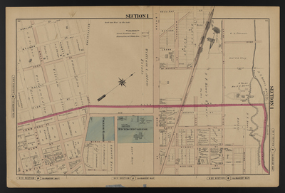
Illustrated combination atlas of Richmond, Va. 1876
Publisher
F.W. Beers
Creation Date
1876
Plate Number
Section I
Description
Published for the Southern and Southwestern Surveying and Pub. Co. by F.W. Beers.
Streets
Birch St.; Bowe St.; Boyd St.; Broad St.; Clay St.; Duncan St.; Extension or Lombardy St.; Extension St.; Floyd St.; Grove St.; Hanover St.; Harvie St.; Holliday St.; Kinney St.; Leigh St.; Lodge St.; Lombardy St.; Marshall St.; McKenzie St.; Meadow St.; Moore St.; Norton St.; Park St.; Plum St.; Rail Road Ave.; Rowland St.; Scuffletown Road; Vine St.; Walnut St.
Features
Bacon Quarter Branch
Notable Structures
College Garden; Richmond College; Richmond Fredericksburg & Potomac Rail Road
Physical Description
46 cm.
Scale
Scale 1 inch=200 feet
Topical Subject
Real property -- Virginia -- Richmond
Geographical Name Subject
Richmond (Va.) -- Maps; Henrico County (Va.) -- Maps
City/Location
Richmond (Va.); Henrico County (Va.)
Temporal
Nineteenth century
Genre
books; maps (documents)
Local Genre
map; text
Type
Still Image; Text
Digital Format
image/jpg
Language
eng
Rights Statement URL
Rights
This material is in the public domain in the United States and thus is free of any copyright restriction. Acknowledgement of Virginia Commonwealth University Libraries as a source is requested.
Original Title
Illustrated atlas of the city of Richmond, Va.
Collection
Illustrated atlas of the city of Richmond, Va.
Source
Beers, F.W. (Frederick W.). 1876. Illustrated atlas of the city of Richmond, Va. Richmond? Va. : F.W. Beers, 1876.
File Name
beers_015.jpg