


Preview
Other Title
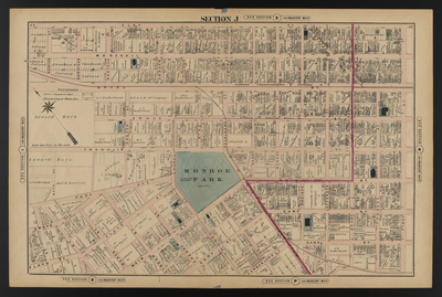
Illustrated combination atlas of Richmond, Va. 1876
Publisher
F.W. Beers
Creation Date
1876
Plate Number
Section J
Description
Published for the Southern and Southwestern Surveying and Pub. Co. by F.W. Beers.
Streets
1st St.; Adams St.; Beach St.; Belvidere St.; Broad St.; Brooke Ave.; Canal St.; Cary St.; Cherry St.; Clay St.; Cumberland St.; Floyd St.; Foushee St.; Franklin St.; Gilmer St.; Grace St.; Graham St.; Grove Ave.; Hancock St.; Harrison St.; Henry St.; Jefferson St.; Laurel St.; Linden St.; Madison St.; Main St.; Marshall St.; Monroe St.; Munford St.; Norton St.; Park Ave.; Pine St.; Shafer St.; Smith St.
Features
Monroe Park
Notable Structures
3rd Baptist Church; Christian Church; Clay Street School; Connection Rail Road Co.; Elba Park Church; Episcopal Chapel; Grace Protestant Episcopal Church; Madison Public School; Presbyterian Church; Richmond City Passenger Railway; Richmond Fredericksburg & Potomac Rail Road; Sidney Methodist Episcopal Church
Physical Description
46 cm.
Scale
Scale 1 inch=200 feet
Topical Subject
Real property -- Virginia -- Richmond
Geographical Name Subject
Richmond (Va.) -- Maps
City/Location
Richmond (Va.)
Temporal
Nineteenth century
Genre
books; maps (documents)
Local Genre
map; text
Type
Still Image; Text
Digital Format
image/jpg
Language
eng
Rights Statement URL
Rights
This material is in the public domain in the United States and thus is free of any copyright restriction. Acknowledgement of Virginia Commonwealth University Libraries as a source is requested.
Original Title
Illustrated atlas of the city of Richmond, Va.
Collection
Illustrated atlas of the city of Richmond, Va.
Source
Beers, F.W. (Frederick W.). 1876. Illustrated atlas of the city of Richmond, Va. Richmond? Va. : F.W. Beers, 1876.
File Name
beers_016.jpg