


Preview
Other Title
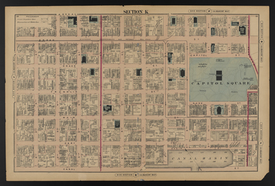
Illustrated combination atlas of Richmond, Va. 1876
Publisher
F.W. Beers
Creation Date
1876
Plate Number
Section K
Description
Published for the Southern and Southwestern Surveying and Pub. Co. by F.W. Beers.
Streets
1st St., North; 1st St., South; 2nd St., North; 2nd St., South; 3rd St., North; 3rd St., South; 4th St., North; 4th St., South; 5th St., North; 5th St., South; 6th St., North; 6th St., South; 7th St., North; 7th St., South; 8th St., North; 8th St., South; 9th St., North; 9th St., South; 10th St., North; 10th St., South; 11th St., North; 11th St., South; 12th St., North; 12th St., South; Bank St.; Basin St.; Broad St.; Canal St.; Capitol St.; Cary St.; Eagle Alley; Franklin St.; Governor St.; Grace St.; Main St.; Market Alley; Market Slip; Marshall St.
Features
Canal Basin; Capitol Square; Old City Hall Lot - Public Square
Notable Structures
7th Street Christ Church; Broad Street Methodist Episcopal Church; Capitol; Centenary Methodist Episcopal Church; Custom House; First Baptist Church; First Presbyterian Church; Governors Mansion; Grace Street Presbyterian Church; Post Office; Roman Catholic Church School; Richmond City Passenger Railway Company; Richmond Fredericksburg and Potomac Rail Road; Second Baptist Church; Second Presbyterian Church; St. James Episcopal Church; St. Joseph Orphan Asylum; St. Paul's Episcopal Church; St. Peters Cathedral; State Courthouse
Wards
Clay Ward; Monroe Ward; Madison Ward; Jackson Ward; Jefferson Ward; Marshall Ward; Manchester
Physical Description
46 cm.
Topical Subject
Real property -- Virginia -- Richmond
Geographical Name Subject
Richmond (Va.) -- Maps
City/Location
Richmond (Va.)
Temporal
Nineteenth century
Genre
books; maps (documents)
Local Genre
map; text
Type
Still Image; Text
Digital Format
image/jpg
Language
eng
Rights Statement URL
Rights
This material is in the public domain in the United States and thus is free of any copyright restriction. Acknowledgement of Virginia Commonwealth University Libraries as a source is requested.
Original Title
Illustrated atlas of the city of Richmond, Va.
Collection
Illustrated atlas of the city of Richmond, Va.
Source
Beers, F.W. (Frederick W.). 1876. Illustrated atlas of the city of Richmond, Va. Richmond? Va. : F.W. Beers, 1876.
File Name
beers_017.jpg