


Preview
Other Title
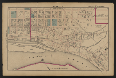
Illustrated combination atlas of Richmond, Va. 1876
Publisher
F.W. Beers
Creation Date
1876
Plate Number
Section M
Description
Published for the Southern and Southwestern Surveying and Pub. Co. by F.W. Beers.
Streets
22nd St.; 23rd St.; 24th St.; 25th St.; 26th St.; 27th St.; 28th St.; 29th St.; 30th St.; 31st St.; 32nd St.; 33rd St.; 34th St.; Ash St.; Cary St.; Denny St.; Elm St.; Franklin St.; Grace St.; Hague St.; Main St.; Maple St.; Nicholson St.; Pear St.; Poplar St.; Rocketts St.; Warehouse St.; Water St.; Wharf St.; Williamsburg Ave.; Williamsburg Turnpike
Features
Chimborazo Hill; Gillies Creek; James River; James River and Kanawha Canal; Marshall Park; Sand Bar; St. John's Burying Grounds; S. Lewis Est. Cemetery
Notable Structures
Chesapeake & Ohio Rail Road Co.; Catholic Nunnery; County Courthouse; Methodist Church; Richmond York River & Chesapeake Rail Road; Sisters of Charity St. Patrick's Church; St. John's Church
Wards
Jackson Ward
Physical Description
46 cm.
Scale
Scale 1 inch=200 feet
Topical Subject
Real property -- Virginia -- Richmond
Geographical Name Subject
Richmond (Va.) -- Maps
City/Location
Richmond (Va.)
Temporal
Nineteenth century
Genre
books; maps (documents)
Local Genre
map; text
Type
Still Image; Text
Digital Format
image/jpg
Language
eng
Rights Statement URL
Rights
This material is in the public domain in the United States and thus is free of any copyright restriction. Acknowledgement of Virginia Commonwealth University Libraries as a source is requested.
Original Title
Illustrated atlas of the city of Richmond, Va.
Collection
Illustrated atlas of the city of Richmond, Va.
Source
Beers, F.W. (Frederick W.). 1876. Illustrated atlas of the city of Richmond, Va. Richmond? Va. : F.W. Beers, 1876.
File Name
beers_019.jpg