


Preview
Other Title
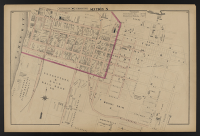
Illustrated combination atlas of Richmond, Va. 1876
Publisher
F.W. Beers
Creation Date
1876
Plate Number
Section N
Description
Published for the Southern and Southwestern Surveying and Pub. Co. by F.W. Beers.
Streets
2nd St.; 3rd St.; 4th St.; 5th St.; 6th St.; 7th St.; 8th St.; Apperson St.; Brown St.; Centre St.; Delaware St.; Denny St.; Erin St.; Franklin or Tompkins St.; Franklin St.; Fulton St.; Gilliam St.; Goddin St.; Graham St.; Hague St.; Highland St.; Hudson St.; Lewis St.; Louisiana St.; Malone St.; Marshall St.; Nicholson St.; Ohio St.; Orleans St.; Osborne Turnpike; Price St.; Rocketts St.; Russell St.; State St.; Tompkins St.; Union St.; Virginia St.; Wharf St.; Wicker St.; Williamsburg Ave.
Features
Gillies Creek; James River; Mount Erin
Notable Structures
Chesapeake & Ohio Rail Road Co.; Fulton Baptist Church; Methodist Church
Wards
Marshall Ward
Physical Description
46 cm.
Topical Subject
Real property -- Virginia -- Richmond
Geographical Name Subject
Richmond (Va.) -- Maps; Henrico County (Va.) -- Maps
City/Location
Richmond (Va.); Henrico County (Va.)
Temporal
Nineteenth century
Genre
books; maps (documents)
Local Genre
map; text
Type
Still Image; Text
Digital Format
image/jpg
Language
eng
Rights Statement URL
Rights
This material is in the public domain in the United States and thus is free of any copyright restriction. Acknowledgement of Virginia Commonwealth University Libraries as a source is requested.
Original Title
Illustrated atlas of the city of Richmond, Va.
Collection
Illustrated atlas of the city of Richmond, Va.
Source
Beers, F.W. (Frederick W.). 1876. Illustrated atlas of the city of Richmond, Va. Richmond? Va. : F.W. Beers, 1876.
File Name
beers_020.jpg