


Preview
Other Title
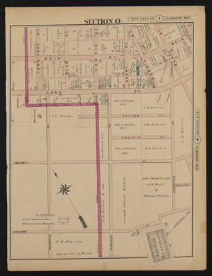
Illustrated combination atlas of Richmond, Va. 1876
Publisher
F.W. Beers
Creation Date
1876
Plate Number
Section O
Description
Published for the Southern and Southwestern Surveying and Pub. Co. by F.W. Beers.
Streets
Ashland St.; Beach St.; Beverly St.; Cary St.; Chaffin St.; Harvie St.; Lombardy St.; Main St.; Morris St.; Plum St.; Randolph St.; Reservoir St.; Short St.; Taylor St.; Wallace St.; Washington St.
Features
Marshall Reservoir
Notable Structures
Sidney Baptist Church (Colored)
Wards
Clay Ward; Jackson Ward
Physical Description
46 cm.
Scale
Scale 1 inch=200 feet
Topical Subject
Real property -- Virginia -- Richmond
Geographical Name Subject
Richmond (Va.) -- Maps; Henrico County (Va.) -- Maps
City/Location
Richmond (Va.); Henrico County (Va.)
Temporal
Nineteenth century
Genre
books; maps (documents)
Local Genre
map; text
Type
Still Image; Text
Digital Format
image/jpg
Language
eng
Rights Statement URL
Rights
This material is in the public domain in the United States and thus is free of any copyright restriction. Acknowledgement of Virginia Commonwealth University Libraries as a source is requested.
Original Title
Illustrated atlas of the city of Richmond, Va.
Collection
Illustrated atlas of the city of Richmond, Va.
Source
Beers, F.W. (Frederick W.). 1876. Illustrated atlas of the city of Richmond, Va. Richmond? Va. : F.W. Beers, 1876.
File Name
beers_021.jpg