


Preview
Other Title
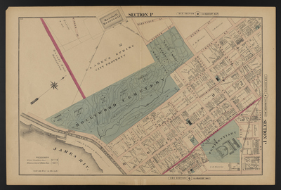
Illustrated combination atlas of Richmond, Va. 1876
Publisher
F.W. Beers
Creation Date
1876
Plate Number
Section P
Description
Published for the Southern and Southwestern Surveying and Pub. Co. by F.W. Beers.
Streets
Adams St.; Albemarle St.; Beach St.; Belvidere St.; Beverly St.; Byrd St.; Canal St.; Cary St.; Cherry St.; China St.; Church St.; Cumberland St.; Dobson St.; Green St.; Holly St.; Laurel St.; Linden St.; Maiden Lane; Pine St.; Reservoir St.; Rowe St.; Spring St.; Winder St.
Features
Hollywood Cemetery; James River; James River and Kanawha Canal; Marshall Reservoir; Pump House Race
Notable Structures
Baptist Church; Methodist Episcopal Church; Protestant Episcopal Church; Penitentiary; Pump House; Richmond Fredericksburg & Potomac Rail Road; Richmond Passenger Railway Company; Sidney Methodist Episcopal Church
Wards
Jackson Ward; Jefferson Ward; Madison Ward; Marshall Ward
Physical Description
46 cm.
Scale
Scale 1 inch=200 feet
Topical Subject
Real property -- Virginia -- Richmond
Geographical Name Subject
Richmond (Va.) -- Maps
City/Location
Richmond (Va.)
Temporal
Nineteenth century
Genre
books; maps (documents)
Local Genre
map; text
Type
Still Image; Text
Digital Format
image/jpg
Language
eng
Rights Statement URL
Rights
This material is in the public domain in the United States and thus is free of any copyright restriction. Acknowledgement of Virginia Commonwealth University Libraries as a source is requested.
Original Title
Illustrated atlas of the city of Richmond, Va.
Collection
Illustrated atlas of the city of Richmond, Va.
Source
Beers, F.W. (Frederick W.). 1876. Illustrated atlas of the city of Richmond, Va. Richmond? Va. : F.W. Beers, 1876.
File Name
beers_023.jpg