


Preview
Other Title
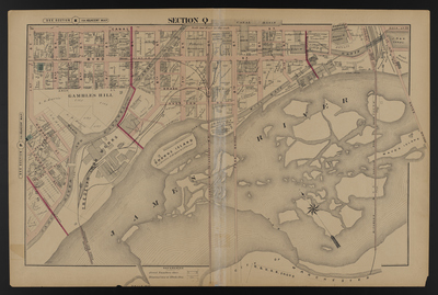
Illustrated combination atlas of Richmond, Va. 1876
Publisher
F.W. Beers
Creation Date
1876
Plate Number
Section Q
Description
Published for the Southern and Southwestern Surveying and Pub. Co. by F.W. Beers.
Streets
1st St.; 2nd St.; 3rd St.; 4th St.; 5th St.; 6th St.; 7th St.; 8th St.; 9th St.; 10th St.; 11th St.; 12th St.; Bragg St.; Byrd St.; Canal St.; Church St.; Dock St.; Free Bridge; High St.; Howard St.; Mayos Bridge; Overton St.; Rowe St.; 14th St., South; Stevenson St.; Virginia St.
Features
Belle Isle; Browns Island; Canal Basin; Gambles Hill; James River; James River and Kanawha Canal; Mayos Island; Mill Race
Notable Structures
2nd Baptist Church Colored; Connection Railroad Tunnel; Methodist Episcopal Church; Richmond & Danville Rail Road; Richmond & Petersburg Railroad; Tredegar Iron Works; Tredegar Iron Works Bridge
Wards
Jefferson Ward; Marshall Ward
Physical Description
46 cm.
Scale
Scale 1 inch=200 feet
Topical Subject
Real property -- Virginia -- Richmond
Geographical Name Subject
Richmond (Va.) -- Maps
City/Location
Richmond (Va.)
Temporal
Nineteenth century
Genre
books; maps (documents)
Local Genre
map; text
Type
Still Image; Text
Digital Format
image/jpg
Language
eng
Rights Statement URL
Rights
This material is in the public domain in the United States and thus is free of any copyright restriction. Acknowledgement of Virginia Commonwealth University Libraries as a source is requested.
Original Title
Illustrated atlas of the city of Richmond, Va.
Collection
Illustrated atlas of the city of Richmond, Va.
Source
Beers, F.W. (Frederick W.). 1876. Illustrated atlas of the city of Richmond, Va. Richmond? Va. : F.W. Beers, 1876.
File Name
beers_024.jpg