


Preview
Other Title
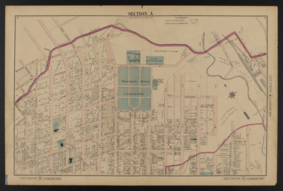
Illustrated combination atlas of Richmond, Va. 1876
Publisher
F.W. Beers
Creation Date
1876
Plate Number
Section A
Description
Published for the Southern and Southwestern Surveying and Pub. Co. by F.W. Beers.
Streets
1st St.; 2nd St.; 3rd St.; 4th St.; 5th St.; 6th St.; 7th St.; 8th St.; 9th St.; 10th St.; 11th St.; Abigail St.; Allen St.; Bacon St.; Baker St.; Bates St.; Brook St.; Calhoun St.; Cave St.; Charity St.; Coutts St.; Duval St.; Federal St.; Hickory St.; Hill St.; Hospital St.; Mill Road; Mitchell St.; N [St.]; New North Road; O [St.]; Orange St.; Peters St.; Potter St.; Preston St.; Road to Fairfield; St. James St.; St. John St.; St. Paul St.; Webster St.
Features
Bacon Quarter Branch; Jewish Burying Ground; Potters Field; Shockoe Creek; Shockoe Hill Cemetery; City Spring
Notable Structures
Alms House; Baker (Colored) School; Chesapeake & Ohio Rail Road; Colored Alms House; Colored Orphan Asylum; Free Baptist Church; Mt. Zion African Church
Physical Description
46 cm.
Scale
Scale 1 inch=200 feet
Topical Subject
Real property -- Virginia -- Richmond
Geographical Name Subject
Richmond (Va.) -- Maps
City/Location
Richmond (Va.)
Temporal
Nineteenth century
Genre
books; maps (documents)
Local Genre
map; text
Type
Still Image; Text
Digital Format
image/jpg
Language
eng
Rights Statement URL
Rights
This material is in the public domain in the United States and thus is free of any copyright restriction. Acknowledgement of Virginia Commonwealth University Libraries as a source is requested.
Original Title
Illustrated atlas of the city of Richmond, Va.
Collection
Illustrated atlas of the city of Richmond, Va.
Source
Beers, F.W. (Frederick W.). 1876. Illustrated atlas of the city of Richmond, Va. Richmond? Va. : F.W. Beers, 1876.
File Name
beers_008.jpg