


Preview
Other Title
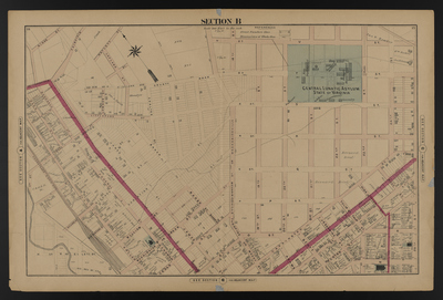
Illustrated combination atlas of Richmond, Va. 1876
Publisher
F.W. Beers
Creation Date
1876
Plate Number
Section B
Description
Published for the Southern and Southwestern Surveying and Pub. Co. by F.W. Beers.
Streets
11th St.; 18th St.; 19th St.; 20th St.; 21st St.; 22nd St.; 23rd St.; 24th St.; 25th St.; Accommodation St.; Adams St.; Baker St.; Balding St.; Buchanan St.; Burton St.; Carrington St.; Cedar St.; Christian St.; Coalter St.; County Road; Ellettt St.; Federal St.; Green St.; Haylett St.; Highland Ave.; James St.; Jay St.; Jessamine St.; Littlepage St.; Lofland St.; Lownes St.; Mechanicsville Turnpike; Mechanicsville Turnpike or Mosby St.; Mosby St.; N or Ellett St.; N [St.]; O St.; P St.; Page St.; Pink or Tyler St.; Pink St.; Q St.; R St.; Richard St.; Road to Fairfield; Rose St.; S St.; Scott St.; T St.; Tulip St.; Tyler St.; U St.; Valley St.; Venable St.; Washington or Green St.; Washington St.; William St.
Features
Old Bed of [Creek]
Notable Structures
Central Lunatic Asylum; Chesapeake & Ohio Rail Road; Christ Episcopal Church; Union Station Methodist Episcopal Church
Physical Description
46 cm.
Scale
Scale 1 inch=200 feet
Topical Subject
Real property -- Virginia -- Richmond
Geographical Name Subject
Richmond (Va.) -- Maps; Henrico County (Va.) -- Maps
City/Location
Richmond (Va.); Henrico County (Va.)
Temporal
Nineteenth century
Genre
books; maps (documents)
Local Genre
map; text
Type
Still Image; Text
Digital Format
image/jpg
Language
eng
Rights Statement URL
Rights
This material is in the public domain in the United States and thus is free of any copyright restriction. Acknowledgement of Virginia Commonwealth University Libraries as a source is requested.
Original Title
Illustrated atlas of the city of Richmond, Va.
Collection
Illustrated atlas of the city of Richmond, Va.
Source
Beers, F.W. (Frederick W.). 1876. Illustrated atlas of the city of Richmond, Va. Richmond? Va. : F.W. Beers, 1876.
File Name
beers_009.jpg